Saturday, October 22, 2005
Alpha? Is that you?
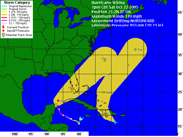
Because why have one storm when you can have two, tropical depression 25 has formed in the eastern Carribean southwest of Puerto Rico. Here are the projected paths of Wilma and TD 25 (potentially soon to be Alpha):

The computer models have be saying on-and-off-again for days that Wilma would recurve after hitting Florida and hit anywhere from NC to Nova Scotia (though it will be severely weakened, but the northeast could do without the rain). Pre-Alpha, while not a direct threat to land, may very well encourage Wilma to do just that.

The computer models have be saying on-and-off-again for days that Wilma would recurve after hitting Florida and hit anywhere from NC to Nova Scotia (though it will be severely weakened, but the northeast could do without the rain). Pre-Alpha, while not a direct threat to land, may very well encourage Wilma to do just that.
Friday, October 21, 2005
Wilma Updates
Wilma is battering the Yucatan at the moment. It doesn't seem to be weakening all that quickly, and the system is moving slowly. At 5 am, the winds were at 150 mph and the central pressure was 930 mb. The pressure actually dropped briefly, but is now up to 932 mb with winds of 140 mph. And that's after buzz-sawing land all day. This area was effected by Emily earlier this year, which was also a category 4 at landfall. Only Wilma is moving slower, which means the wind and rain will last longer, especially at the rate it is weakening. So how will this look on Sunday evening?
The official forcast has it emerging in the Gulf as a category 2 on Saturday evening. But the longer it stays over land, the weaker it gets. So basically, the more battered the Yucatan gets, the better off Florida will be.
Update, Sunday, Oct. 23, 9:30 AM - Hurricane force winds have finally moved offshore of the Yucatan, though tropical storm force winds are effected both the Yucatan and Cuba. Wilma is now a solider category 2 with 100 mph winds and a central pressure of 961 mb. And the official forcast has been moved west, acknowledging the potential for the remants to make landfall in Canada or the Northeast U.S. by mid-week. It's still uncertain if Wilma will strengthen before hitting Florida, but intensity predictions are always the most difficult to make.
I heard a report on the radio that up to 4 feet of rain has fallen in some places, though I'm having difficulty finding official storm totals. Florida will hopefully not have to deal with high amounts of rain, since Wilma will be moving much faster when it hits there.
Update, Monday, Oct. 24, 8:00 AM - Wilma has made landfall as a category 3 hurricane in southwestern Florida. It looks like it missed the southern Keys, but judging by radar, the eyewall may hit Miami while Wilma is a weak category 3 or strong category 2. Palm Beach is also at risk.
Update, Monday,Oct. 24, 5:45 PM - Wilma refuses to die. She weakened to a strong category 2 when passing over Florida, but quickly restrengthened to a solid category 3 after emerging in the Atlantic. It's looking less likely now that she will effect the U.S. again, though Canada should keep an eye on this system.
Rainfall totals in some parts of Florida reached up to ten inches, and that was with the eye being over land for less than 12 hours. 35% of Key West is under water. Of course, as with any hurricane, it may be several days before a real picture of the damage starts to come into focus. However, I think western Cuba got the worst deal in all of this, though it's certainly in a tough competition with the Yucatan. Tropical storm force winds wipped them as Wilma swept over the Yucatan and continued to effect them as it turned toward Florida. They also got plenty of rain. They may never have gotten hurricane force winds, but tropical storm force winds for nearly three days combined with buckets of rain is no picnic either.
Thursday, October 20, 2005
Go Hokies!
Virginia Tech is playing Maryland at Maryland tonight. Since I don't have tickets, I'm hiding out in my apartment to avoid the traffic and the burning couches.
Go Hokies!
Update: 28-9. That was uuuuuuuuugly. But at least we didn't lose. Now let's do it again tomorrow morning, flag football style!
Go Hokies!
Update: 28-9. That was uuuuuuuuugly. But at least we didn't lose. Now let's do it again tomorrow morning, flag football style!
Where's My Batman??????????
I ordered Batman Begins from Amazon. Today, I supposedly received a package. However, when the front desk went in search of said package, they couldn't find it. I went to check on my order from Amazon, and the tracking information was unavailable. If somebody stole my DVD before it even entered my hands, I may be forced to hurt someone. Although, that someone would probably just end up being myself, seeing as how my bruises from this weekend have yet to move past the "no touching!" stage. Never fly through the air without the aid of a grappling gun. It's simply unwise.
Update: Got it! Fear the bat!
Update: Got it! Fear the bat!
Wednesday, October 19, 2005
Now that's what I call instensification!
When I went to bed last night, Wilma has 100 mph winds and a central pressure of 954 mb. This morning, she's got 175 mph winds and a central pressure of 882 mb! That's the lowest pressure in an Atlantic hurricane ever, the previous record being 888 mb. There was an 85 mb drop in just 12 hours. That's just insane.
Is there any way we could maybe ship some iceburgs from Alaska to the Gulf of Mexico? That thing has fueled way too many monster storms this year.
Is there any way we could maybe ship some iceburgs from Alaska to the Gulf of Mexico? That thing has fueled way too many monster storms this year.
Tuesday, October 18, 2005
Monday, October 17, 2005
Quote of the Day - October 17, 2005
Like any good reporter, I believe that if you're not scared, I'm not doing my job.
- Steve Colbert, The Colbert Report
- Steve Colbert, The Colbert Report
Wilma is Born
It's official. Tropical Storm Wilma has formed in the Carribbean. We've tied the record for number of tropical storms in the Atlantic basin. Computer models have it either hitting the Yucatan by Friday or Florida sometime next week. And it will most likely reach hurricane strength before making landfall, wherever it hits.
Sunday, October 16, 2005
What Kind of World Do We Live In?
Childrens toys often reflect the mundane, from fake telephones that really ring to plastic food in tot-sized play-kitchens, toys let kids pretend they are grow-ups. So what kind of world are we living where security check-points enter into the world of children's play? (link thanks to Dave Barry's blog)
I also love how 11% of people who viewed that toy ended up buying a Getaway Car instead.
I also love how 11% of people who viewed that toy ended up buying a Getaway Car instead.


